
Last Updated on March 16, 2024
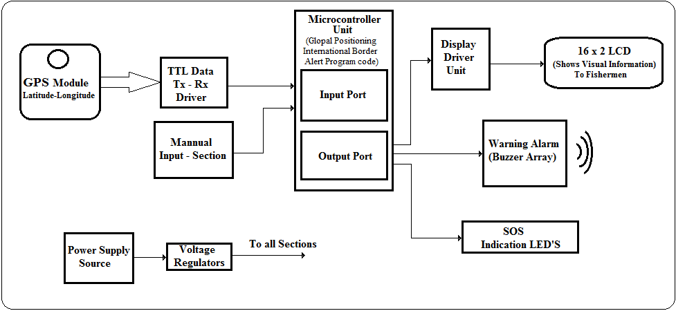
BLOCK DIAGRAM
ABSTRACT
GPS based border alert system aims in keeping an end for the killings of the fishermen were seen quite common in the boundary coastal areas which has become quite common these days. The reason for this they were crossing the territory or boundary. This happening due to lack of awareness where their boundary is located and the cost of this mistake is their life and we cannot provide any sign board in the mid of the sea to solve this problem. The only solution which we provide for this problem is enabling the boats with a GPS device.
GPS based boarder alert system gives a best solution for this problem, whenever the fisherman was about to reach the boundary he can have an alert. So that he can go back from that point onwards.
The GPS is the acronym for Global Positioning System. This GPS receiver is capable of identifying the location in which it was present in the form of latitude and longitudes. This information is very useful and can be processed for alerting the boat drivers. The GPS gives the data received from the satellites. For this information the GPS communicates with at least three satellites in the space. The functioning of the device is achieved by employing a micro controller.
The micro controller forms the controlling unit of the project. The micro controller is interfaced with a GPS receiver so that it can receive theinformation about the location in which the boat is present. The controller compares the location of the boat with the territory location. Whenever the boat approaches the boundary it alerts the driver. It is also interfaced with few LED indicators to alert the boat driver.